New Zealand and Tectonic Processes
New Zealand has three main islands, the North Island, the South Island, and Stewart Island. These islands were once part of the supercontinent Gondwana, which broke off from the even larger supercontinent of Pangea about 250 million years ago (Gondwana). Over time, Gondwana began to break up into different landmasses. The New Zealand subcontinent--the majority of which is underwater--eventually drifted to its current location along the border of the Australian and Pacific plates (Walrond).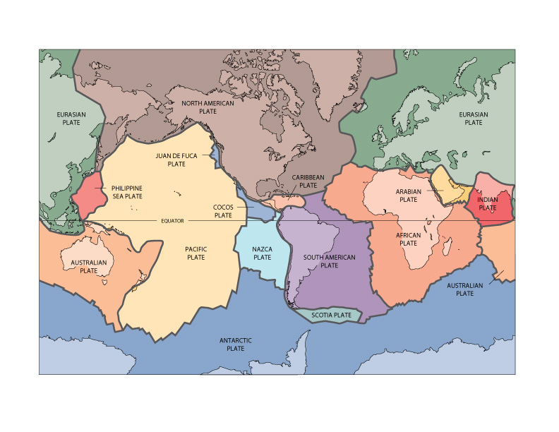 | ||||
| New Zealand is positioned on the boundary between the Australian and Pacific plates. http://pubs.usgs.gov/gip/dynamic/slabs.html |
New Zealand’s position along a plate boundary is responsible for the large amount of seismic activity the country experiences. The North Island and the northern tip of the South Island sit on the Australian plate, while the rest of the South Island is on the Pacific Plate. As the two plates converge, the dense oceanic crust of the Pacific plate is being subducted beneath the lighter continental crust of the Australian plate (McSaveney). This subduction is responsible for the uplift of the mountain ranges in New Zealand, many of which were once beneath the ocean (Tectonic). New Zealand’s highest mountains, the Southern Alps, were created by the Alpine Fault, which runs directly along this plate boundary. When the stress between the colliding rock becomes too great, the fault ruptures, causing a massive earthquake. Scientists believe that there is a 30 percent probability that the Alpine Fault will rupture in the next 50 years, which will cause equally massive results to the natural and human environment (Alpine).
 |
| A satellite image of the Alpine Fault and the Southern Alps http://www.gns.cri.nz/Home/Learning/Science-Topics/Earthquakes/Major-Faults-in-New-Zealand/Alpine-Fault |
Tectonic features like the Alpine Fault are common throughout New Zealand as it lies within a “deforming plate boundary zone”, meaning that its shape is continually being changed by the interaction between the plates. The deformation is less than 1 millimeter per kilometer per year, but in geological time that adds up! After conducting research on New Zealand’s deformation between 1994 to 1998 the firm GNS Science produced a movie which illustrates how New Zealand’s shape could change over the next four million years (Deformation). Click on the link below to watch it:
 |
| Me enjoying a cup of tea with the Southern Alps in the background. |
Works Cited
“Alpine Fault.” GNS Science. N.p., n.d. Web. 15 Sept. 2014
“Deformation of New Zealand.” GNS Science. N.p., n.d. Web. 15 Sept. 2014
"Gondwana: The Great Supercontinent." Parks and Wildlife Service Tasmania. N.p., Oct. 2010.
Web. 15 Sept. 2014.
McSaveney, Eileen. “Earthquakes - Seismic activity in New Zealand.” Te Ara - the Encyclopedia
of New Zealand. N.p. 13 Jul. 2012. Web. 15 Sept. 2014.”
“Tectonic Uplift.” GNS Science. N.p., n.d. Web. 15 Sept. 2014.
Walrond, Carl. “Natural environment - Geography and geology.” Te Ara - the Encyclopedia of New
Zealand. N.p. Aug. 2013. Web. 15 Sept. 2014.